Yosemite National Park
Yosemite: more than 1 million square miles of park in California.
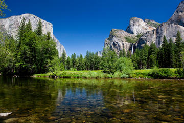
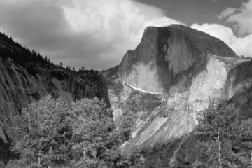
A national treasure protected by the park system with giant sequoia trees, majestic waterfalls and spectacular granite cliffs. Located two hours west of Modesto, it’s beauty was captured by Ansel Adams in some of the country’s most iconic photos. Highlights of the park include Bridalveil Fall, Half Dome and El Capitan.
Open / Close / Reopening Status of Yosemite National Park due to Coronavirus (COVID-19)
Last Updated: May 2, 2020
Busiest Months (Percentage of Annual Visits)
Wawona
A settlement and thoroughfare which was added to Yosemite National Park in 1932. It contains the authentic Victorian Big Trees Lodge (formerly Wawona Hotel), the Wawona Visitor Center at Hill’s Studio, Pioneer Yosemite History Center and access to nearby Mariposa Grove.
Mariposa Grove
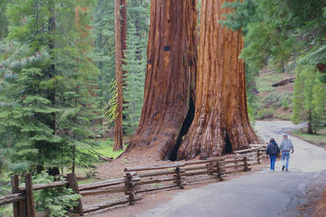
The largest of three sequoia groves in Yosemite with more than 500 mature giant sequoias. A popular destination in the park, though the area is closed through Summer 2017 for a restoration project.
Tuolumne Meadows
A large sub-alpine meadow surrounded by majestic mountain peaks and home to the winding Tuolumne River.
Hetch Hetchy
A valley and a reservoir in the northwest corner of Yosemite National Park that is just over an hour by car from Yosemite Valley. Although this glacier-carved valley once resembled the awe-inspiring Yosemite Valley, Congress in 1913 permitted San Francisco to dam the Tuolumne River to provide water for the Bay Area.
El Capitan
A vertical rock of sheer granite on the northwest side of Yosemite Valley. It rises about 3,600 feet above the valley floor. The moderately used hiking trail is a 14+ mile out and back that is difficult and only recommended for in-shape hikers. For climbers, El Capitan is one of the ultimate challenges in the world. It is also one of the most photographed sections of Yosemite.
Half Dome
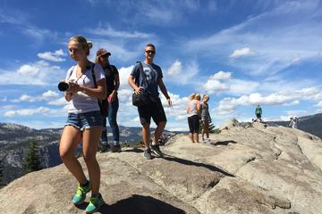
Half Dome is a popular destination for a round trip hike of about 15 miles for those who are in shape and prepared. It rises 5,000 feet above Yosemite Valley. In 1865, a report concluded that it would never be trodden on by human foot.
Now, it is done on a daily basis. A maximum of 225 day hikers and 75 backpackers are allowed on the trail up Half Dome each day. Permits are required. Backpackers apply for a Half Dome permit with their wilderness permit if they are starting in the park. If they are starting outside the park, then they apply for it through the process for day hikers. Day Hikers apply through a preseason lottery or the daily lottery. The daily lottery makes available about 50 permits each day due to cancellations and under-utilization.
Tunnel View
This iconic view of Yosemite Valley on State Route 41 was made famous by Ansel Adams. The overlook opened in 1933.
Glacier Point
This scenic overlook is located at the end of Glacier Point Road, 3,200 feet above Half Dome Village at an elevation of 7,214 feet. It is a popular 32 mile drive from Yosemite Valley, but parking can be a challenge. It is also accessible by the Yosemite buses. The road usually closes due to snow in November and reopens in late May or early June.
Taft Point
A 2.2 mile roundtrip hike from the parking area off Glacier Point Road brings visitors to a scenic overlook of Yosemite Valley from a sheer cliff. There are two classic Yosemite photo spots here at the end of the trail. It is named for President William Howard Taft, who visited Yosemite in 1909 with John Muir and came across the point.
Yosemite Waterfalls
There are more than twenty waterfalls in the park, although some are only visible during the runoff of melting snow from March through June.
Yosemite Falls: One of the world’s tallest waterfalls is composed of three sections as Yosemite Creek falls 2,425 feet. The upper section alone is one of the twenty highest waterfalls in the world. The waterfall is at its highest in late spring due to snow runoff. There is a viewing area at the bottom of the Lower Yosemite Fall and the top of the Upper Yosemite Fall is accessible by Yosemite Falls Trail, one of the oldest trails in Yosemite and a strenuous 7.2 mile roundtrip hike with an elevation gain of 2,700 feet.
Bridalveil Fall: Bridalveil is the first waterfall seen when entering Yosemite Valley and one of the most photographed in the park. Although the 620 foot drop in Bridalveil Creek can be seen year round and is heaviest in spring, it is known for the windswept look that resembles a bride’s veil when the snow runoff has subsided.
Sentinel Falls: Sentinel is a tiered waterfall with six major drops as it cascades 2,000 feet in the south side of Yosemite Valley along Sentinel Rock. It is usually visible from March through June.
Horsetail Fall: This waterfall which can be seen from December through April is best known for its reflections of the orange sunset in mid to late February.
Yosemite Climbing
Yosemite National Park is one of the premier places for rock climbing and bouldering in the United States. It is considered the birthplace of American rock climbing as well as multi-day climbing. The Half Dome and El Capitan are both epic climbs. Bouldering, which is usually done on rocks available 15 or fewer feet above the ground, is also popular at Camp 4, Tuolumne Meadows and Candyland.
Yosemite Backpacking
June and July are the peak months for wilderness backpacking. The most popular overnight destination is Little Yosemite Valley. For serious hikers, take the John Muir Trail for 211 miles from Happy Isles through Kings Canyon and Sequoia to the top of Mt. Whitney.
Permits are required as there are daily trailhead quotas. Permits can be obtained up to 24 weeks in advance. 40% of permits are reserved from advanced reservations and available on a first-come, first-served basis at several locations in the park starting at 11 AM on the day before.
Yosemite Trout Fishing
Lakes and reservoirs are available for fishing year round while stream and river fishing is open from late April until mid-November. Rules vary depending on location and elevation. Try trout fishing in the Merced River, the Tuolumne River or while boating in Tenaya Lake.
Swimming in Yosemite
Sandy beaches for swimming are located at several alpine lakes and local rivers, including the Merced River, Tuolumne River, and Tenaya Creek. The water can be chilly, however. Swimming is prohibited above waterfalls and at Hetch Hetchy Reservoir. There are also swimming pools for a nominal fee at Curry Village and Yosemite Lodge from Memorial Day to Labor Day.
Hiking Trails:
Recent Bird Sightings
Weather Forecast:
[wunderground location=”Yosemite Valley, CA” numdays=”4″ layout=”simple” showdata=”search,alert,daynames,highlow,pop,icon,text,conditions,date”]
Average Temperature (Monthly)
Radar:
Camping in Yosemite
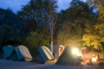
Yosemite National Park campgrounds are a popular place to stay.
There are seven campgrounds where reservations are allowed. Nearly all reservations Yosemite campgrounds for the months of May through September and some other popular weekends are filled the first day they become available and it can occur within minutes of opening to reservations. Reservations open on the 15th of each month at 7 AM Pacific time for a one month block up to five months in advance.
There are also first-come, first-served campgrounds but they fill up fast. There are very few available campsites in May/June and you must typically be at a campground by mid-morning at the latest to get a spot. Camp 4 and Tuolumne Meadows generally are staffed while other first-come, first-serve areas have a self-registration system.
Campground Reservations:
Some Hotels and Other Lodging Options:
Vacation Packages:
Round Trip Flights to San Francisco
[tp_in_our_city_fly_shortcodes destination=SFO title=”” limit=15 paginate=false stops=2 one_way=false off_title=true subid=”” currency=”USD”]
Shop:
Yosemite National Park
Glacier Point
Hetch Hetchy
Taft Point
Yosemite Airport
Yosemite Firefall
Yosemite Weddings
American Samoa
Arches
Badlands
Big Bend
Biscayne
Black Canyon
Bryce Canyon
Canyonlands
Capitol Reef
Carlsbad Caverns
Channel Islands
Congaree
Crater Lake
Cuyahoga Valley
Death Valley
Denali
Dry Tortugas
Everglades
Gates of the Arctic
Glacier Bay
Glacier
Grand Canyon
Grand Teton
Great Basin
Great Sand Dunes
Great Smoky Mountains
Guadalupe Mountains
Haleakala
Hot Springs
Hawaii Volcanoes
Hot Springs
Isle Royale
Joshua Tree
Katmai
Kenai Fjords
Kings Canyon
Kobuk Valley
Lake Clark
Lassen Volcanic
Mammoth Cave
Mesa Verde
Mount Rainier
North Cascades
Olympic
Petrified Forest
Pinnacles
Redwood
Rocky Mountain
Saguaro
Sequoia
Shenandoah
Theodore Roosevelt
Virgin Islands
Voyaguers
Wind Cave
Wrangell-St. Elias
Yellowstone
Yosemite
Zion


